current weather for El Segundo (United State)
El Segundo is located near Manhattan Beach at 2mi↑, Del Aire at 3mi↑, Hawthorne at 4mi↑, Lennox at 4mi↑, Hermosa Beach at 4mi↑,
Elevation : 128ft
currently : 63°F overcast at El Segundo

The current temperature is 63°F, the felt temperature is 63°F.
Wind direction from West with a speed of 2mph with gusts at 4mph.
The air is extremely humid : relative air humidity is 86 %.
Pressure is 30inHg.
weather last updated 5790 minutes
Sun rises in 2h41 and the sun is setting in 16h2. The duration of the night is 10h39.
For more details on weather observations and short-term forecasts, see the aeronautical weather provided by Los Angeles International airport.

Coming to El Segundo
Hotels : book on Hotels.com Booking Expedia Abritel Stay22
Taxi : book on Taxi Booking
activities : Getyourguide
By plane :
- Los Angeles International airport at 2mi : book on Iberia Singapore Airlines Condor
southwest_airlines cathay_pacific
- Jack Northrop Field Hawthorne Municipal airport at 5mi : book on Trip.com
- Santa Monica Municipal airport at 7mi : book on Trip.com
Weather forecast for El Segundo (United State)
Monday, June 1, 2026
Sky will be covered with cloud all the night and the day will be cloudy but the sun will appear.
the temperature will range from 63°F to 66°F
wind speed up to 10mph
7h
62°F
Overcast
The air is extremely humid : relative air humidity is 86 %.
pressure is 30inHg
Wind direction from South 2mph with gusts at 2mph
10h
62°F

Overcast
The air is extremely humid : relative air humidity is 83 %.
pressure is 30inHg
Wind direction from South West 3mph with gusts at 2mph
13h
64°F

Broken clouds
The air is very humid : relative air humidity is 73 %.
pressure is 30inHg
Wind direction from South West 8mph with gusts at 5mph
16h
66°F

Sky clear
The air is very humid : relative air humidity is 65 %.
pressure is 30inHg
Wind direction from South West 10mph with gusts at 7mph
19h
65°F

Scattered clouds
The air is very humid : relative air humidity is 69 %.
pressure is 30inHg
Wind direction from South West 10mph with gusts at 10mph
22h
63°F
Sky clear
The air is extremely humid : relative air humidity is 83 %.
pressure is 30inHg
Wind direction from South West 8mph with gusts at 8mph
Tuesday, June 2, 2026
Sky will be mainly clear but cloud will appear and the day will be cloudy but the sun will appear.
the temperature will range from 63°F to 68°F
wind speed up to 11mph
1h
62°F

Sky clear
The air is extremely humid : relative air humidity is 81 %.
pressure is 30inHg
Wind direction from South West 6mph with gusts at 6mph
4h
62°F

Few clouds
The air is extremely humid : relative air humidity is 83 %.
pressure is 30inHg
Wind direction from South 3mph with gusts at 3mph
7h
62°F
Scattered clouds
The air is extremely humid : relative air humidity is 84 %.
pressure is 30inHg
Wind direction from South 3mph with gusts at 4mph
10h
64°F
Few clouds
The air is very humid : relative air humidity is 79 %.
pressure is 30inHg
Wind direction from South 5mph with gusts at 4mph
13h
68°F
Scattered clouds
The air is very humid : relative air humidity is 67 %.
pressure is 30inHg
Wind direction from South West 6mph with gusts at 4mph
16h
68°F
Broken clouds
The air is very humid : relative air humidity is 69 %.
pressure is 30inHg
Wind direction from South West 11mph with gusts at 10mph
19h
68°F
Broken clouds
The air is very humid : relative air humidity is 69 %.
pressure is 30inHg
Wind direction from South West 9mph with gusts at 10mph
22h
65°F
Sky clear
The air is very humid : relative air humidity is 79 %.
pressure is 30inHg
Wind direction from South West 6mph with gusts at 7mph
Wednesday, June 3, 2026
Sky will be clear all night long and the day will be sunny.
the temperature will range from 64°F to 72°F
wind speed up to 9mph
1h
65°F
Sky clear
The air is very humid : relative air humidity is 79 %.
pressure is 30inHg
Wind direction from South East 6mph with gusts at 7mph
4h
65°F
Sky clear
The air is very humid : relative air humidity is 79 %.
pressure is 30inHg
Wind direction from South East 7mph with gusts at 9mph
7h
64°F
Sky clear
The air is extremely humid : relative air humidity is 83 %.
pressure is 30inHg
Wind direction from South East 5mph with gusts at 6mph
10h
66°F
Sky clear
The air is very humid : relative air humidity is 77 %.
pressure is 30inHg
Wind direction from South East 5mph with gusts at 5mph
13h
71°F
Sky clear
The air is very humid : relative air humidity is 63 %.
pressure is 30inHg
Wind direction from South 6mph with gusts at 5mph
16h
72°F
Sky clear
The air is very humid : relative air humidity is 64 %.
pressure is 30inHg
Wind direction from South West 9mph with gusts at 7mph
19h
69°F
Sky clear
The air is very humid : relative air humidity is 68 %.
pressure is 30inHg
Wind direction from South West 7mph with gusts at 7mph
22h
65°F
Sky clear
The air is very humid : relative air humidity is 79 %.
pressure is 30inHg
Wind direction from South West 4mph with gusts at 4mph
Thursday, June 4, 2026
Sky will be clear all night long and the day will be cloudy but the sun will appear.
the temperature will range from 64°F to 70°F
wind speed up to 11mph
1h
65°F
Sky clear
The air is extremely humid : relative air humidity is 81 %.
pressure is 30inHg
Wind direction from South East 5mph with gusts at 6mph
4h
64°F
Sky clear
The air is extremely humid : relative air humidity is 83 %.
pressure is 30inHg
Wind direction from South East 6mph with gusts at 7mph
7h
64°F
Sky clear
The air is extremely humid : relative air humidity is 87 %.
pressure is 30inHg
Wind direction from South East 4mph with gusts at 5mph
10h
66°F
Few clouds
The air is extremely humid : relative air humidity is 81 %.
pressure is 30inHg
Wind direction from South East 7mph with gusts at 8mph
13h
70°F
Sky clear
The air is very humid : relative air humidity is 69 %.
pressure is 30inHg
Wind direction from South 9mph with gusts at 9mph
16h
69°F
Broken clouds
The air is very humid : relative air humidity is 70 %.
pressure is 30inHg
Wind direction from South 10mph with gusts at 9mph
19h
67°F
Broken clouds
The air is very humid : relative air humidity is 74 %.
pressure is 30inHg
Wind direction from South 9mph with gusts at 8mph
22h
65°F
Overcast
The air is very humid : relative air humidity is 79 %.
pressure is 30inHg
Wind direction from South 6mph with gusts at 6mph
Today Friday, June 5, 2026
Sky will be covered with cloud all the night and the day will be cloudy from morning to evening.
the temperature will range from 64°F to 68°F
wind speed up to 9mph
1h
64°F
Overcast
The air is extremely humid : relative air humidity is 81 %.
pressure is 30inHg
Wind direction from South 5mph with gusts at 5mph
4h
64°F
Overcast
The air is extremely humid : relative air humidity is 80 %.
pressure is 30inHg
Wind direction from South East 7mph with gusts at 8mph
7h
64°F
Overcast
The air is extremely humid : relative air humidity is 81 %.
pressure is 30inHg
Wind direction from South East 4mph with gusts at 5mph
10h
64°F
Overcast
The air is very humid : relative air humidity is 79 %.
pressure is 30inHg
Wind direction from South 5mph with gusts at 6mph
13h
68°F
Overcast
The air is very humid : relative air humidity is 70 %.
pressure is 30inHg
Wind direction from South 7mph with gusts at 7mph
16h
68°F
Overcast
The air is very humid : relative air humidity is 69 %.
pressure is 30inHg
Wind direction from South West 10mph with gusts at 7mph
19h
66°F
Overcast
The air is very humid : relative air humidity is 73 %.
pressure is 30inHg
Wind direction from South West 9mph with gusts at 7mph
22h
64°F
Overcast
The air is very humid : relative air humidity is 77 %.
pressure is 30inHg
Wind direction from South West 5mph with gusts at 5mph
Saturday, June 6, 2026
Sky will be covered with cloud all the night and the day will be cloudy from morning to evening.
the temperature will range from 63°F to 63°F
wind speed up to 6mph
1h
63°F
Overcast
The air is extremely humid : relative air humidity is 80 %.
pressure is 30inHg
Wind direction from South 4mph with gusts at 4mph
4h
63°F
Overcast
The air is extremely humid : relative air humidity is 81 %.
pressure is 30inHg
Wind direction from South East 5mph with gusts at 6mph
Weather observation and forecast provided by OpenWeatherMap under CC BY-SA 4.0 license amended by aviation weather data.
near
- Hotels in El Segundo
- Renaissance Philadelphia Downtown Hotel (Philadelphia) at 2402mi↑
- MoMA (New York) at 2460mi↑
- Théâtre Mogador (Paris) at 5657mi↑
- Palais Garnier (Paris) at 5657mi↑
- Le Matissia (Paris) at 5658mi↑
- Théâtre de La Porte Saint-Martin (Paris) at 5658mi↑
- Paris at 5659mi↑
- for Chevron Refinery airport at 1mi↑
- for Pacific Corporate Towers airport at 1mi↑
- for Towers Number 2 airport at 1mi↑
Weather news
Tuesday, February 10, 2026
news
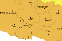
Storm Nils is arriving in the Hautes-Pyrénées
Météo France has issued an orange alert bulletin for Wednesday night to Thursday with winds that could exceed 100 km/h in the Hautes-Pyrénées.
Saturday, May 8, 2021
news
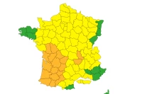
Weather alert for thunderstorms and strong winds in the southwest
Météo-France has placed the southwest on orange alert for strong winds and thunderstorms. The winds have already begun to gust early this afternoon. But the worst is yet to come.
Tuesday, October 20, 2020
news
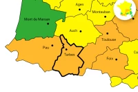
Alerte orange sur les Hautes-Pyrénées, la tempête Barbara arrive
Le vent a commencé à souffler sur la façade ouest avec des vents à près de 200 km/h. Ce n'est que le début et Météo France a émis un bulletin d'alerte orange pour vent violent sur les…
Monday, October 19, 2020
news
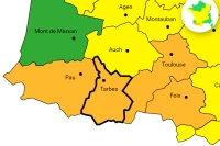
La tempête Barbara souffle à plus de 150 km/h sur les Hautes-Pyrénées
Le vent a commencé à souffler sur la façade ouest avec des vents à près de 200 km/h. Ce n'est que le début et Météo France a émis un bulletin d'alerte orange pour vent violent sur les…