The heavy rains that fell in Tarbes last night and this morning will continue until Monday. And will even intensify, as Météo-France announced in the bulletin issued this morning. After last night's stormy wave, where thunderstorms were occasionally very active, a lull is emerging early this morning in the north, but on the contrary, thunderstorm activity has already resumed, particularly in southern Aquitaine
. An orange alert bulletin is issued for the duration of the sustained rains as well as their fairly extensive geographical area, which make this event exceptional. The quantities forecast in 24/48 hours could thus approach the hundred-year values in some places
. Météo-France predicts that the phenomenon will intensify in the coming hours. Starting this Sunday morning, the new rain and thunderstorm deterioration will begin in the southwest. The rains, often moderate, sometimes heavy, then spill over from the Pyrenees into the plains, as far as the Garonne Valley, and take on a stormy character. Between Sunday afternoon and Monday noon, periods of heavy precipitation follow one another, producing significant, sometimes exceptional, accumulations in the southwest, where their repetition and duration are the dominant issue, with the stormy nature being drowned out by the mass. A few wind gusts of around 60-70 km/h are possible, as well as hailstorms during the most violent storms.
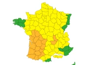
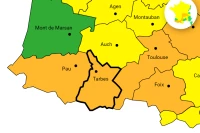
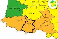
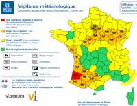
The Hautes-Pyrénées and 17 other departments are on orange alert until Monday noon
The entire southwest will be affected, as announced in the orange alert bulletin, which covers Charente-Maritime, Gers, Gironde, Lot-et-Garonne, Pyrénées-Atlantiques, and Hautes-Pyrénées. And even more broadly, as it also affects Indre-et-Loire, Landes, Loir-et-Cher, and Loiret, to which Paris and the inner suburbs, Seine-et-Marne, Yvelines, Essonne, and Val-d'Oise have just been added. Météo-France is forecasting heavy rain and thunderstorms in Nouvelle-Aquitaine this afternoon and tomorrow morning. Rainfall rates could frequently reach 20 to 30 mm per hour. Over the entire episode, 50 to 100 mm are expected, almost universally, in the departments placed on orange alert. From the Basque Piedmont/Bigorre to Armagnac and the Arcachon Basin, it is even possible that local rainfall amounts could reach 100 to 150 mm (equivalent to 1 to 2 months of precipitation) in less than 36 hours, which corresponds to return periods sometimes in the order of 100 years.
Ile-de-France will also be affected
Departments further north will also be impacted, such as the Centre-Val de Loire region, with strong thunderstorms expected in the evening and high rainfall intensities of around 20 to 30 mm/h, which could cause runoff flooding. Cumulative rainfall amounts expected in less than 24 hours average 30 to 50 mm and will locally exceed 70 mm. And in the Île-de-France region, the weather will quickly become unstable again, particularly during the afternoon and evening, with frequent thunderstorms that could locally bring hail, numerous thunderstorm impacts, and once again heavy accumulations. Météo-France specifies that their occurrence will be very heterogeneous from one location to another. And during the next night, a new very rainy disturbance will reach the region from the southeast. The expected accumulations are very heterogeneous, but they could quite frequently reach 20 to 40 mm and locally 30 to 50 or even 60 mm moving towards the southeast (Essonne and southern Seine-et-Marne in particular). Météo-France adds that storm axes may affect all areas on Sunday, placed on yellow alert for thunderstorms, with heavy precipitation accompanying them, but producing lower accumulations, sometimes a little hail, and a few gusts of wind
. Weather conditions are not expected to last until midday on Monday, with improvement expected Monday afternoon.


